Biking Guide: 5 Spectacular Road Rides in and around Park City
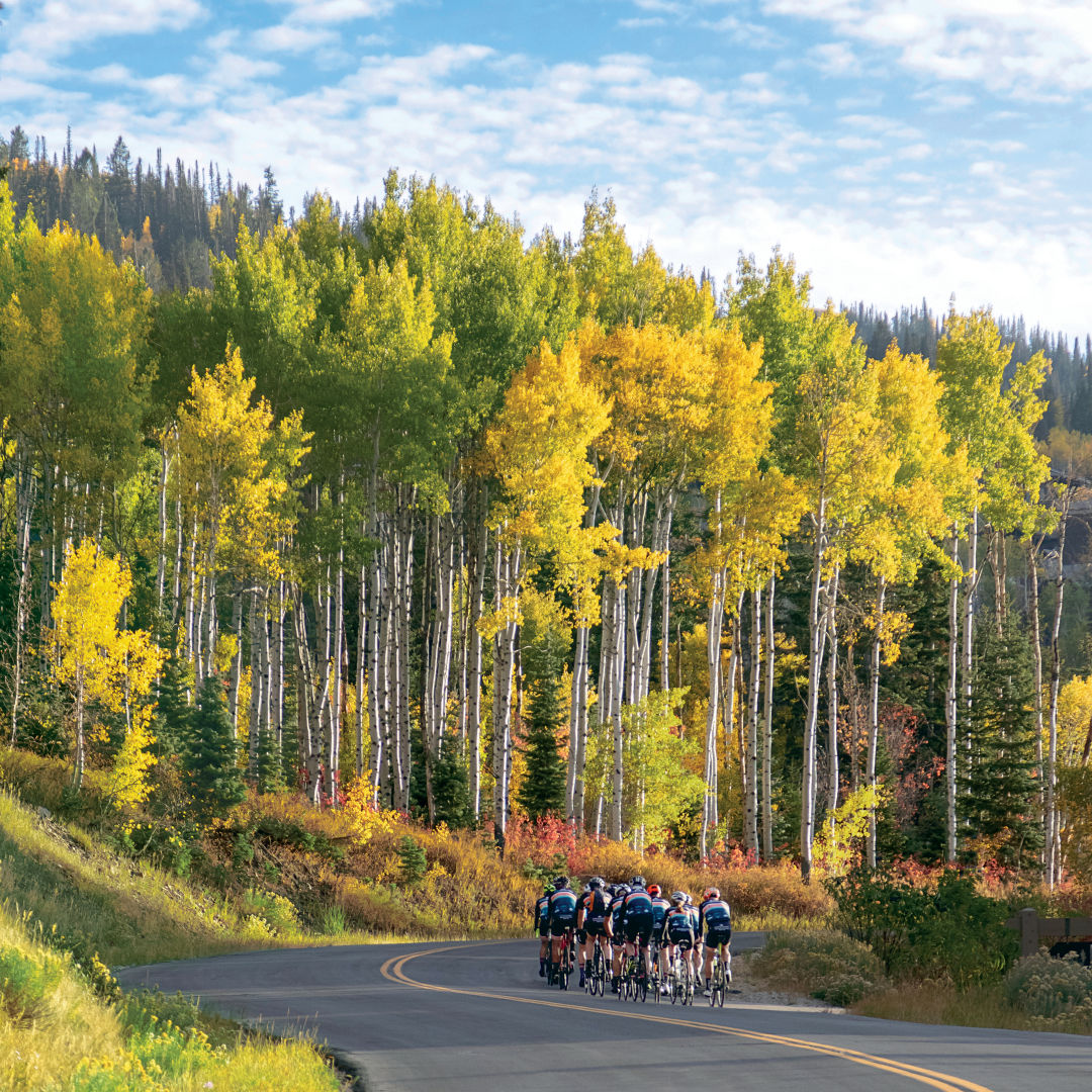
Guardsman Loop is both grueling, in terms of vertical grind, and tremendous thanks to bird’s-eye views.
Image: Eric Schramm
Ed Note: In spring and fall, snow levels may prevent cyclists from completing some of the higher altitude loops in this guide. Be sure to check road conditions and closures, before hitting the pavement.
Road cycling in these parts can be ridiculously stunning in terms of scenery, but given the topography of the landscape, it also involves a fair amount of elevation gain. As Todd Henneman of Storm Cycles notes, “If you like to climb, you’re in the right place.”
Empire (a.k.a. Guardsman) Loop
Length: 35 miles
Find it: Start on Kearns Blvd (Hwy 248), heading east toward Kamas.
Take in some jaw-to-the-floor views—and steep uphill—with this heart-pumping, grueling ride. Head out of town on Highway 248 toward pastoral Kamas, approximately 14 miles. Roll past some pastures, and turn right onto Lambert Lane, then right onto Hill Top Road, then right onto SR 32, which turns into River Road after crossing Hwy 40 (look for fly-fishermen as you near the Provo banks). Then, turn right onto Pine Canyon Road and dig in for a serious climb, skirting Wasatch Mountain State Park and up to Guardsman Pass. When the road comes to a T above Midway, take a right and ascend to the summit overlooking Deer Valley Resort’s chutes, the state park, and beyond. Take a breath in the thin air (well above 9,000 feet at this point) and then start the fun descent down Hwy 224 (Marsac Avenue), either continuing to Old Town via the fast mine road or taking Wheaton’s Way connector (on the right, just before the old silver mine) to switchback down Royal Street and return to Old Town via Deer Valley Drive.
Brown’s Canyon Loop
Length: 30 miles
Find it: Start on Kearns Boulevard (Hwy 248), heading east toward Kamas.
Roll into rural Summit County as you hop off of Highway 248 onto North Democrat Alley (2000 W) via a left turn, a quieter cruise (i.e., virtually no traffic). You will encounter a small section where asphalt gives way to some packed road base, but the majority is hard surface with more cows and horses than vehicles along the way. Turn left onto Wooden Shoe Lane into Peoa (keep an ear out for a concert in the park), which turns into SR 32. Turn left up Brown’s Canyon and pop back onto busy Highway 248 for the return to the “big” city.
Old Ranch Road/Home Depot Loop
Length: 15–16 miles, depending on route
Find it: From Old Town, head north on Highway 224 and turn right onto Old Ranch Road, shortly after passing the Canyons base of Park City Mountain.
Quick with relatively limited elevation gain, this close-to-town loop is perfect for getting acquainted with the local landscape. Weave through Old Ranch Road—past neighborhoods, alfalfa pastures, and horse property—turn right at the frontage road (Highland Drive), and then turn left to cross over Highway 40. Take a right in front of Home Depot on the frontage road back to the intersection with Highway 248, and turn right to head back into town. Or, get away from vehicular traffic and do not hop over Highway 40, instead taking Highland Drive to the paved Silver Quinn’s Trail. Continue on the trail system past the Park City Ice Arena and under Highway 248, and turn right onto the Rail Trail—thereby staying on trails rather than heavily traveled road back into town.
Weber Canyon (out and back)
Length: 60 miles or more, depending on how far out one rolls
Find it: Start on Highway 248 and take Brown’s Canyon to Wooden Shoe Lane, which turns into Rob Young Ln (W 3700 N). Then, turn left on SR 32 and continue straight through on N New Lane, and turn right on Weber Canyon.
This tree-lined country ride leads to Smith and Morehouse Reservoir, part of the Uinta-Wasatch-Cache National Forest land, which means the occasional camper may overtake a Weber Canyon–bound cyclist. But for the most part, this is peaceful pedaling. Once you arrive at the Smith and Morehouse turnoff, the rest of the ride is hard-packed gravel. Doable, and worth the cruise for an off-the-grid sojourn (and perhaps a quick dip in the reservoir before the return to civilization). Consider stopping at the Road Island Diner (981 West Weber Canyon Road, 435.783.3467, roadislanddiner.com) for a shake on the return trip back through Oakley.
Wolf Creek Pass (out and back)
Length: 80-ish miles
Find it: Park at the South Summit Aquatic Center in Kamas (or ride there via Highway 248 and SR 32 through Kamas for extra miles).
Think sunflower-strewn meadows and backside views of the Uinta-Wasatch-Cache National Forest. Start this adventure on Lower River Road to Woodland, then take a right at the red church onto Bench Creek Road, and continue onto SR 35 to Wolf Creek Pass. Crank those pedals a total of 50 miles to Hanna, or keep going. The road is paved all the way to Duchesne, 30 miles farther. On the return, reward all that pedaling with a stop at Woodland Biscuit Company (2734 E SR 35, Woodland, 435.783.4202, woodlandbiscuitcompany.com).
Before you go
Mountain weather is changeable, so layer up. Take altitude into consideration; don’t be afraid to stop for your oxygen-depleted lungs’ sake or to make way for a moose, and bring plenty of water and snacks to avoid bonking. Grab a Mountain Trails Foundation (mountaintrails.org) map, available at most sports retailers and coffee shops (or online) to plot your route, or download Trailforks or MTB Project apps for real-time GPS guidance. And consider purchasing a copy of Park City’s Prime Cuts 3, the newest edition of the go-to trail guidebook by longtime local riders Paul Boyle, Mark Fischer, and Charlie Sturgis (available at local retailers).
Special thanks to Scott House of White Pine Touring, Charlie Sturgis of Mountain Trails Foundation, Ben Liegert of Snyderville Basin Recreation, Todd Henneman of Storm Cycles, and Chris Erkkila of Deer Valley Resort for sharing trail- and road-riding expertise.
(See individual bike option articles divided by levels of expertise.)