Biking Guide: 5 Easy Rides for Cruising Park City's Trails
The Farm Trail parallels McLeod Creek Trail for roughly 2 miles and can be accessed via the Highway 224 underpass.
Riding in the Wasatch typically involves climbing. While some of these trails are flattish, any singletrack adventures mentioned here involve some level of aerobic workout and may even require a little technique. “Easy,” when it comes to mountain riding, doesn’t necessarily mean breezy.
The Historic Union Pacific Rail Trail
Length: 28 miles (one way)
Find it: Roll onto the trail from Old Town via the Poison Creek Trail (and the underpass below Bonanza Drive), or park at the Prospector Trailhead.
Freewheel this gradual downhill ride on Utah’s first nonmotorized trail, designated a state park in 1992, which now travels where rail once carried coal and silver ore across the county. Today’s trail runs through wetlands (listen for the red-winged blackbird) and neighborhoods before entering less-populated stretches of ranchland, paralleling Interstate 80, as it meanders through Wanship and Coalville, ending at Echo Reservoir. Take the return trip’s gradual uphill into account as you’re breezily cruising toward Echo.
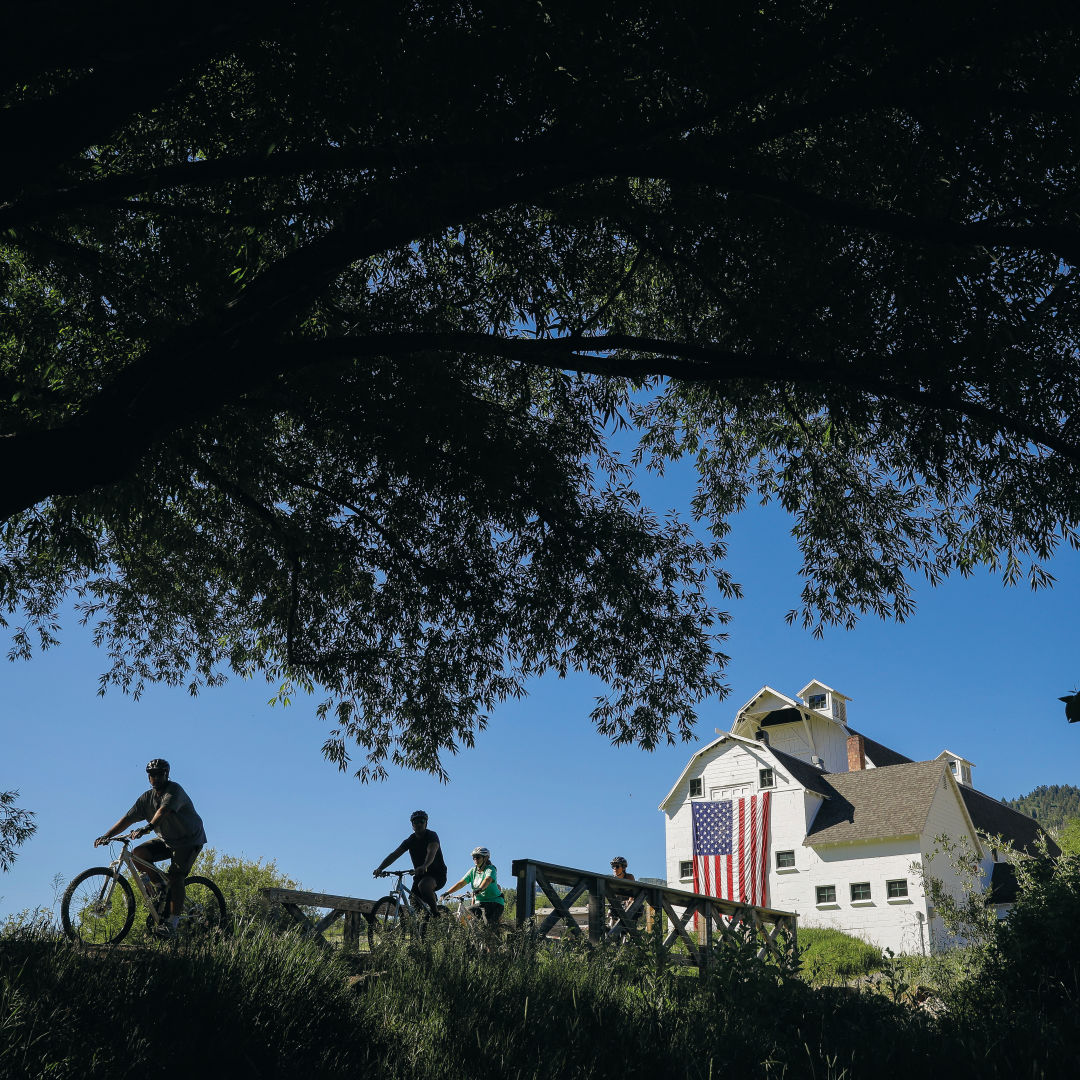
McLeod Creek Trail
Length: 4 miles
Find it: From Old Town, hop aboard the paved path alongside Highway 224, or start at the McPolin Farm Trailhead. Or reverse the ride and start in Kimball Junction or at the Willow Creek Trailhead.
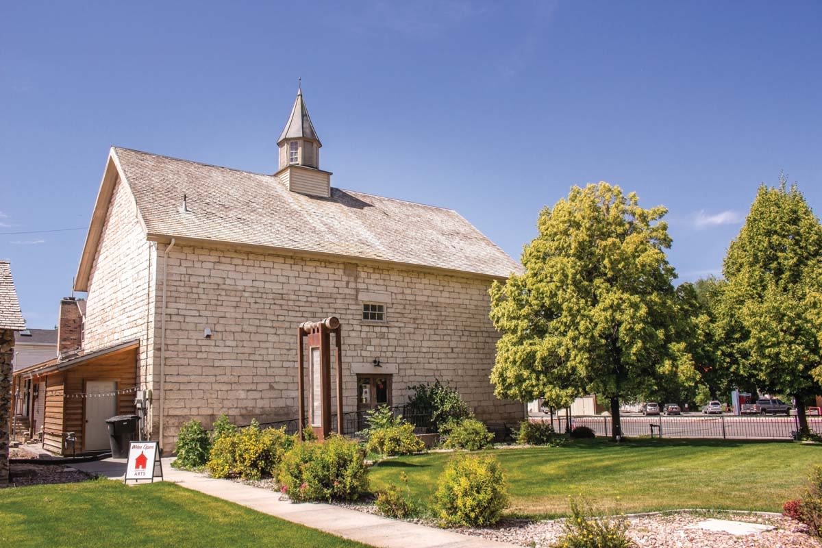
Cruising from town toward Kimball Junction, this wide, initially paved trail rolls alongside its bubbling namesake, past the iconic white barn (McPolin Farm), and then veers right behind Temple Har Shalom onto packed dirt, past an interactive musical sculpture, through a shady, rural stretch, and across Old Ranch Road to Willow Creek Park, where playgrounds, sports fields, and picnic tables make for a family-friendly destination. Add on some mileage by continuing onto Willow Creek Loop and East 224 Connector Trail all the way to Kimball Junction for a reward at I Love Moo, Smoothies Too (1634 Uinta Way, 435.602.1177, ilovemooparkcity.com) or a scoop of locally made Wasatch Creamery ice cream at Hugo Coffee Shop (1794 Olympic Pkwy, 435.655.5015, hugo.coffee)
Round Valley: PorcUclimb-Downward Dog Loop
Length: 7-mile loop
Find it: Park at Quinn’s Trailhead
Round Valley’s 700 acres of sagebrush-scented, preserved open space contains a delightful web of trails, leading to a vast array of rides. This loop starts with a wide, flat trail and gradually adds some slightly narrower trails, with a wee helping of learner-friendly, directional switchbacks thrown into the mix. Begin on Fast Pitch, connect to Ability Way, take a little uphill on Matt’s Flat to the hilltop at Seventy 101, then switchback up PorcUclimb (uphill only), take a right onto Nowhere Elks at the top, then look for the Downward Dog descent (downhill only) all the way until it intersects with Matt’s Flat singletrack, and ride back to Ability Way via Matt’s Access Trail, left on Ability Way Connector to Fast Pitch, then to Hat Trick and—tada!—back to where you started. Don’t forget to pause along the way for the panoramic resort views and potential glimpses of moose, deer, hares, hawks, and wildflowers. Consider branching out to other Round Valley favorites: Rusty Shovel, Rambler, and Pulp Friction.
Trailside Loop
Length: 1-mile loop
Find it: Trailside Park, adjacent to the bike park
Extremely beginner-friendly, this loop is conveniently located next to the all-levels, skills-honing bike park (see article on Bike Parks). This subtly graded singletrack curves through sagebrush-covered terrain, allowing for ample visibility as newbies get into the dirt-riding groove. Once you’ve mastered the loop and bike park, consider heading into neighboring Round Valley terrain.
RTS
Length: 2.5 miles
Find it: Park at RTS trailhead on Olympic Parkway.
Located on a 316-acre swath of open space just below Utah Olympic Park’s ski jumps, RTS is ideal for beginners. Gently sloped switchbacks—sans loose rocks—allow for a pleasant roll through open aspen groves and meadows. RTS is also a great launching point for the progressively more challenging terrain of BLT, OMH, and BYOB, and you can access significantly more advanced riding along conifer-topped loops across Olympic Parkway.
Before you go
Mountain weather is changeable, so layer up. Take altitude into consideration; don’t be afraid to stop for your oxygen-depleted lungs’ sake or to make way for a moose, and bring plenty of water and snacks to avoid bonking. Grab a Mountain Trails Foundation (mountaintrails.org) map, available at most sports retailers and coffee shops (or online) to plot your route, or download Trailforks or MTB Project apps for real-time GPS guidance. And consider purchasing a copy of Park City’s Prime Cuts 3, the newest edition of the go-to trail guidebook by longtime local riders Paul Boyle, Mark Fischer, and Charlie Sturgis (available at local retailers).
Special thanks to Scott House of White Pine Touring, Charlie Sturgis of Mountain Trails Foundation, Ben Liegert of Snyderville Basin Recreation, Todd Henneman of Storm Cycles, and Chris Erkkila of Deer Valley Resort for sharing trail- and road-riding expertise.
(See individual bike option articles divided by levels of expertise.)